Interstate 87
|
|
||||
|---|---|---|---|---|
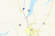
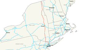 Map of the northeastern United States with I-87 highlighted in red |
||||
| Route information | ||||
| Maintained by NYSTA and NYSDOT | ||||
| Length: | 333.49 mi[2] (536.70 km) | |||
| Existed: | August 14, 1957[1] – present | |||
| Major junctions | ||||
| South end: | ||||
| North end: | ||||
| Highway system | ||||
|
Main route of the Interstate Highway System Numbered highways in New York
|
||||

Interstate 87 (I-87) is a 333.49-mile (536.70 km) intrastate Interstate Highway located entirely within New York in the United States. It is the longest intrastate Interstate Highway in the Interstate Highway System. Its southern end is at the Bronx approach to the Robert F. Kennedy Bridge in New York City. The northern end is at the Canada – United States border in Champlain, where it continues into Quebec as Autoroute 15, which connects it to Montreal. I-87 connects with I-95 in New York City, New York State Route 17 (NY 17; future I-86) near Harriman, I-84 near Newburgh, and I-90 in Albany. The portion of I-87 between the New York City line and Albany is part of the New York State Thruway. North of Albany, I-87 is named the Adirondack Northway.
Contents |
Route description
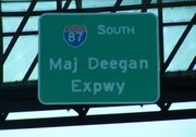
Major Deegan Expressway
Interstate 87 begins at an intersection with the Bruckner Expressway (I-278) at the Robert F. Kennedy Bridge. For the next 8.4 miles (13.5 km), Interstate 87 is known as the Major William Francis Deegan Expressway, which travels through the Bronx. The first exit along the Major Deegan northbound is for Willis Avenue and the nearby Third Avenue Bridge. There is an exit before this going southbound, for Brook Avenue. At 1.20 miles (1.93 km), Grand Concourse interchanges at exit 3. East 149th Street is the next exit, which heads into the heart of the Bronx. Exit 5, which is signed for East 161st Street, actually lets off at Jerome Avenue, near Yankee Stadium. Exit 6 is only accessible via exit 5 (going northbound) and is for East 153rd Street. Exit 7 is for the Cross Bronx Expressway and Trans-Manhattan Expressway, both of which are signed as I-95 and US 1. Exit 8 is for West 179th Street, which becomes Burnside Avenue soon after. Exit 9 parallels the Major Deegan for ending at West Fordham Road.
U.S. Route 9 now parallels the Major Deegan, which is accessible via exit 10 for West 230th Street. Interstate 87 then enters Van Cortlandt Park and interchanges with Van Cortlandt Park South at exit 11. Exit 12 is for the Henry Hudson Parkway and Saw Mill River Parkway, both of which are accessible by the Mosholu Parkway. Exit 13 is for East 233rd Street and Jerome Avenue. Exit 14 is at the northern end of Van Cortlandt Park, is for McLean Ave. The Major Deegan Expressway crosses into Westchester County at Yonkers and becomes the New York State Thruway, a 496-mile (798 km), state-wide toll highway.
New York State Thruway
The section of highway between the New York City line and the junction with Interstate 90 at Albany is part of the New York State Thruway. Interstate 87 enters Westchester at Yonkers. The first exit going northbound is for Hall Place, while going southbound it is for McLean Avenue. (McLean Avenue is exit 14 going northbound on the Major Deegan. There is no southbound exit 14.) Yonkers Avenue interchanges at 9.80 miles (15.77 km). Present just off exit 2 is Yonkers Raceway. Exit 3 is for Miles Square Road, which interchanges just after the Cross County Shopping Center. Exit 4 is for the Cross County Parkway, which interchanges just after the shopping center. Exit 5 follows a frontage road, which heads for NY 100 and the Sprain Brook Parkway. Soon after, Tuckahoe Road interchanges just before leaving Yonkers. Exit 6A is for Stew Leonard Drive, which is just a road for Sprain Ridge Park.
.jpg)
As Interstate 87 heads northward, NY 9A begins to parallel, interchanging at exit 7. The Saw Mill River Parkway is also parallel, intersecting at exit 7A. Before exit 8, the Ardsley Service Area is accessible northbound. Exit 8 is for Interstate 287, beginning a concurrency for the next 19 miles (31 km). The exit is also the access for the Cross-Westchester Expressway. Exit 9 is the final exit before the Tappan Zee Bridge. The exit is for NY 119 and the nearby U.S. Route 9. All trucks with Class A and Class B explosives must leave at exit 9. Interstates 287 and 87 cross the Tappan Zee and enter Rockland County.
Interstate 87 begins a 25-mile (40 km) stretch in Rockland County. Exit 10 is the first exit after the Tappan Zee and is for U.S. Route 9W in Nyack. Exit 11 is in downtown Nyack, for Route 9W going northbound and NY 59 going southbound. 87 then passes the Mountainview Nature County Park as it reaches exit 12, which is located in the outskirts of Nyack. Exit 12 is a folded-diamond interchange for NY 303 and Palisades Center Mall. The first highway in 9.63 miles (15.50 km) interchanges at exit 13, the Palisades Interstate Parkway.
The road has three current spur routes: I-287 connects with its parent in a 19-mile (31 km) long concurrency near the southern end of the highway, with I-87 signed as south–north, and I-287 signed as east–west. It is a partial beltway around New York City. West of the concurrency at exit 15, it loops around New York to meet the New Jersey Turnpike in Middlesex County, New Jersey. East of the concurrency, I-287 continues as the Cross Westchester Expressway to end at I-95 (the New England Thruway) in Rye, New York, near the Connecticut border. Note that I-287 leaves New York state, while its parent does not, making I-287 one of only a few three-digit interstates that goes through more states than its parent. Moving north, I-587 is less than 2 miles (3.2 km) long. It is unusual in that it has no interchanges along its length: its eastern terminus is at a signalized intersection, while its western terminus is at a roundabout (where it connects to Interstate 87). Because there is no direct exit from I-87 into Albany, the 15 km long Interstate 787 serves traffic from the Thruway into the city.
Adirondack Northway
North of Albany, Interstate 87 is known as the Adirondack Northway (or simply the Northway) and continues all the way to the Canada – United States border at Champlain. I-87 joins the Northway at exit 1; however, the Northway begins 0.86 miles (1.38 km) south of the I-87 / I-90 interchange at U.S. Route 20 in Guilderland. This short expressway spur, known locally as Fuller Road Alternate,[2] is designated as NY 910F, an unsigned reference route, by the New York State Department of Transportation.[2]
Between exits 2 and 4, I-87 closely parallels Wolf Road, a business thoroughfare through the town of Colonie. Wolf Road forks from I-87 at the cloverleaf interchange of I-87 exit 2 and runs along the eastern edge of the expressway to exit 4 (County Route 151, Albany Shaker Road) southeast of Albany International Airport. Wolf Road serves as a main access point for Colonie Center, one of the Capital District's largest enclosed shopping malls, from I-87. Between exit 1 (where I-87 begins on the Northway) and exit 22 (at Lake George) I-87, both north and south, is a six-lane corridor.
The southern portion of the Northway through Colonie and Saratoga County is now a heavily traveled commuter route. Since the highway's construction, Saratoga County has become the fastest growing area of the Capital District, and indeed all of upstate New York.[3]
In Lake George, I-87 connects to US 9 and New York State Route 9N at exit 22 by way of a short two-lane highway known infrequently as the Lake George Connector. It's here where the first signs of Quebec Autoroute 15 are posted as motorists head North to Canada. From here the Northway becomes four lanes all the way to the Canadian border (with the highway, both north and south slightly becoming six lanes once again just before the customs).
At milepost 100 on southbound I-87, there is a United States Customs border patrol station. This was added after the 2001 terrorist attacks.
In Clinton County, exit signs from exit 34 to 43 are bilingual in English and French because of its proximity to Quebec. Also, signs for Quebec Autoroute 15 are posted on I-87 North as the Northway approaches the Canadian border.
History
Interstate 87 was assigned on August 14, 1957, as part of the establishment of the Interstate Highway System.[1] The highway initially utilized the pre-existing New York State Thruway from Albany to Newburgh and in lower Westchester County, and the Major Deegan Expressway in New York City. From Newburgh to the Elmsford area, I-87 was to follow a new highway paralleling U.S. Route 9 northward along the eastern bank of the Hudson River to Fishkill. I-87 would then follow the proposed I-84 across the Hudson to rejoin the Thruway outside of Newburgh. Meanwhile, the entirety of the Adirondack Northway, the portion of I-87 slated to extend from Albany north to the Canada – United States border, had yet to be built.[4][5]
Adirondack Northway
The Northway was built in segments, which became I-87 as they were completed and linked to the pre-existing route. Construction began in the late 1950s on the portion of the Northway between the Thruway and NY 7 near Latham.[6] This segment was open to traffic by 1960, by which time work had begun on two additional segments from Latham to Malta (at NY 67) and from US 9 in northern Saratoga County to US 9 and NY 149 midway between Glens Falls and Lake George.[5] The expressway was completed between Latham and Clifton Park (NY 146) and from US 9 south of Glens Falls to the Hudson River ca. 1961.[7] Work on the Latham–Malta and US 9 – NY 149 segments concluded ca. 1962.[8] Construction on the portion of highway between the two segments began ca. 1962 and was completed by 1964. During this same period, another extension brought the northern terminus of the Northway to NY 9N south of Lake George.[7][8][9]
By 1966, the Northway was completed from Albany north to Lake George and from the Canadian border south to Keeseville. At the time, I-87 curved around the outskirts of Lake George to end at NY 9N north of the village[10] on a highway built ca. 1964.[11] The last section of the Northway to be built—a 30-mile (48 km) stretch between Underwood (exit 30) and Keeseville (exit 34)—was completed in spring 1968. I-87 was reconfigured slightly near Lake George as a result: instead of heading east to NY 9N, it continued north on a parallel routing to US 9.[12] I-87's former routing to NY 9N, known infrequently today as the Lake George Connector, is now NY 912Q, an unsigned reference route 0.66 miles (1.06 km) in length. NY 912Q has one intermediate interchange with US 9.[2] The completion of I-87 linked New York City to Montreal by way of a direct, limited-access highway (with I-87 becoming Autoroute 15 at the Canadian border).
Parade Magazine designated the Northway as America's Most Scenic Highway in 1967. In 2007, the New York State Department of Transportation (NYSDOT) ceremonially designated the entire 176-mile (283 km) Northway as the Adirondack Veterans' Memorial Highway.
A long stretch of the Northway through the Adirondack Park has been a dark zone for cell phone service. In 2007, a driver crashed off the road was unable to summon help, prompting calls from local officials to add new wireless towers to address the problem, and warning signs to inform drivers of the dark zone.[13] Throughout this area, roadside emergency call boxes are located approximately every two miles on both sides of the roadway. These boxes use a 2-way UHF radio network to connect directly to New York State Police dispatch. The first of 13 new cell towers along I-87 was installed in October 2008. A second was brought online one month later.[14]
Fuller Road Alternate, the lone portion of the Adirondack Northway not part of I-87, was originally intended to be part of the Southern Albany Expressway, a proposed highway which would have connected the Northway to Interstate 787 and run parallel to the New York State Thruway between exits 23 and 24.[15]
Lower Hudson Valley
By 1962, the plan to route I-87 along the proposed Hudson River Expressway had been scrapped. Instead, I-87 was now proposed to begin in Port Chester and follow a new routing through Purchase, Armonk, and Katonah to Brewster, where it would join I-84.[16] The routing was modified slightly by 1968: I-87 still began in New York City, then overlapped with Interstate 287 east to Purchase. From there, I-87 headed north along the now-open expressway to Armonk, where it ended at NY 22. Another portion of the highway, from Goldens Bridge (NY 138) to Brewster, was open as well while the part from Armonk to Katonah was under construction.[12] This segment, as well as the part from Katonah to Goldens Bridge, was completed by 1971.[17]
On January 1, 1970, I-87 was rerouted between Elmsford and Newburgh to follow the mainline of the Thruway instead. The former routing of I-87 between Purchase and Brewster was then redesignated as Interstate 684.[18]
Future
The New York State Department of Transportation is constructing a single-point urban interchange at Northway exit 6 to replace the current diamond interchange.[19]
A project is in the early stages of design to improve access to the Albany International Airport, either by constructing a new exit 3, or by reconfiguring exit 4. As of January 2010, the project is expected to be completed in late 2015.[20]
Exit list
South of Albany
See Major Deegan Expressway for exits in New York City and New York State Thruway for exits between New York City and Albany.
I-90 overlap
The entirety of the overlap with Interstate 90 is in Albany, Albany County.
| Mile[2] | Exit | Destinations | Notes |
|---|---|---|---|
| 0.00 | I-87 joins I-90 northbound and leaves I-90 southbound | ||
| 0.54 | 1S | Access via NY 910F | |
| 0.62 | 1N | I-87 leaves I-90 northbound and joins I-90 southbound | |
| 1.000 mi = 1.609 km; 1.000 km = 0.621 mi | |||
Northway
This exit list includes the segment of the Northway designated as NY 910F. Note that mile markers begin from where I-87 leaves the Thruway, and not the mileage from the highway's beginning in New York City.
| County | Location | Mile[2] | Exit | Destinations | Notes |
|---|---|---|---|---|---|
| Albany | Guilderland | 0.00 | At-grade intersection with a single lane flyover ramp serving eastbound to northbound traffic | ||
| Albany | 0.49 | Crossgates Mall Road | Southbound exit and northbound entrance | ||
| 0.86 0.00 |
1 | To New York State Thruway; southbound I-87 follows westbound I-90 | |||
| Village of Colonie | 1.39 | 2W-E | |||
| Town of Colonie | 3.30 | 4 | NY 155 west (Albany-Shaker Road) | Serves Albany International Airport | |
| 4.27 | 5 | NY 155 east (Watervliet-Shaker Road) | |||
| 5.53 | 6 | NY 7 joins northbound and leaves southbound | |||
| 6.12 | 7 | NY 7 leaves northbound and joins southbound | |||
| Saratoga | Halfmoon/Clifton Park town line |
10.33 | 8 | Crescent Road (CR 92) / Vischers Ferry Road (CR 90) | CR 92 becomes CR 90 at junction |
| Clifton Park | 11.76 | 8A | Grooms Road (CR 91) | ||
| 13.30 | 9 | Signed as exits 9W (west) and 9E (east) southbound | |||
| 16.22 | 10 | Ushers Road — Jonesville, Ballston Lake | |||
| Malta/Round Lake town line |
18.79 | 11 | Curry Avenue / Round Lake Road (CR 80) | CR 80 terminates here, only Round Lake is designated as such | |
| Malta | 21.05 | 12 | Roundabouts at tops of ramps replaced signals in 2006 | ||
| 24.81 | 13N-S | ||||
| Saratoga Springs | 28.86 | 14 | NY 9P – Saratoga Springs, Schuylerville | Parclo hybrid, Saratoga Race Course | |
| 30.67 | 15 | NY 50 – Saratoga Springs, Gansevoort | |||
| Wilton | |||||
| 36.15 | 16 | Ballard Road (CR 33) - Wilton | |||
| Moreau | 40.94 | 17N-S | |||
| Warren | Queensbury | 45.49 | 18 | Glens Falls, Corinth | |
| 47.83 | 19 | NY 254 (Aviation Road) – Glens Falls, Queensbury | |||
| 50.11 | 20 | NY 149 – Fort Ann, Whitehall | |||
| Southern extent of Adirondack Park | |||||
| Town of Lake George | 53.31 | 21 | |||
| 55.35 | 22 | ||||
| 59.79 | 23 | Diamond Point Road | |||
| Town of Warrensburg | 68.21 | 24 | Bolton Landing-Riverbank Road | ||
| Chester | 73.58 | 25 | |||
| 78.12 | 26 | ||||
| Essex | Schroon | 82.36 | 27 | ||
| 89.07 | 28 | NY 74 – Ticonderoga, Crown Point | |||
| North Hudson | 95.01 | 29 | Boreas Road/Blue Ridge Road | ||
| 104.85 | 30 | ||||
| Westport | 117.99 | 31 | |||
| Lewis | 123.75 | 32 | Stowersville Road — Lewis, Willsboro | ||
| Chesterfield | 135.43 | 33 | |||
| Clinton | Au Sable | 139.22 | 34 | ||
| Northern extent of Adirondack Park | |||||
| Peru | 144.97 | 35 | NY 442 (Bear Swamp Road) – Peru, Valcour, Port Kent | ||
| Town of Plattsburgh | 150.58 | 36 | |||
| 153.51 | 37 | ||||
| 155.31 | 38S-N | ||||
| 156.87 | 39 | NY 314 / Moffitt Road – Cumberland Head, Plattsburgh Bay | Signed as exits 39N (north) and 39E (east) southbound | ||
| Beekmantown | 160.64 | 40 | NY 456 – Beekmantown, Point au Roche | ||
| Chazy | 168.26 | 41 | NY 191 – Sciota, Chazy | ||
| Town of Champlain | 174.75 | 42 | |||
| 176.02 | 43 | ||||
| 176.70 | United States-Canada border; I-87 continues north as A-15 | ||||
| 1.000 mi = 1.609 km; 1.000 km = 0.621 mi | |||||
Auxiliary routes
|
|||||||
References
- ↑ 1.0 1.1 American Association of State Highway Officials (August 14, 1957). Official route numbering for the National System of Interstate and Defense Highways [map].
- ↑ 2.0 2.1 2.2 2.3 2.4 2.5 "2008 Traffic Volume Report for New York State" (PDF). New York State Department of Transportation. June 16, 2009. pp. 142–144, 261, 263. https://www.nysdot.gov/divisions/engineering/technical-services/hds-respository/NYSDOT_Traffic_Volume_Report_2008.pdf. Retrieved January 30, 2010.
- ↑ Aaron, Kenneth (October 3, 2004). "Growing predicament". Times Union (Albany, New York). http://timesunion.com/AspStories/storyprint.asp?StoryID=291354. Retrieved January 31, 2010.
- ↑ Esso (1958). New York with Special Maps of Putnam–Rockland–Westchester Counties and Finger Lakes Region [map], 1958 edition. Cartography by General Drafting.
- ↑ 5.0 5.1 Gulf (1960). New York and New Jersey Tourgide Map [map]. Cartography by Rand McNally and Company.
- ↑ Esso (1954). New York with Special Maps of Putnam–Rockland–Westchester Counties and Finger Lakes Region [map], 1955–56 edition. Cartography by General Drafting.
- ↑ 7.0 7.1 Sunoco (1961). New York and Metropolitan New York [map], 1961–62 edition. Cartography by H.M. Gousha Company.
- ↑ 8.0 8.1 Esso (1962). New York with Sight-Seeing Guide [map]. Cartography by General Drafting.
- ↑ Sinclair (1964). New York and Metropolitan New York [map]. Cartography by Rand McNally and Company.
- ↑ Lamy, Margaret (May 18, 1966). "Big Gaps Are Being Closed in the Link Between the Thruway and Canada". The New York Times. http://select.nytimes.com/gst/abstract.html?res=FA0716FC3C5F137A93CAA9178ED85F428685F9. Retrieved May 13, 2009.
- ↑ Federal Highway Administration (2008). "Structure 1033530". National Bridge Inventory. United States Department of Transportation. http://nationalbridges.com/nbi_record.php?StateCode=36&struct=000000001033530. Retrieved January 3, 2010.
- ↑ 12.0 12.1 Esso (1968). New York [map], 1969–70 edition. Cartography by General Drafting.
- ↑ "DOT to Erect Signs on N'thway Noting Limited Cell Service". WTEN (Albany, New York). January 19, 2008. http://www.wten.com/Global/story.asp?S=7746034. Retrieved January 31, 2010.
- ↑ Smith Dedam, Kim (November 21, 2008). "Verizon lights up second I-87 cell tower". Press-Republican (Plattsburgh, New York). http://www.pressrepublican.com/archivesearch/local_story_326224629.html. Retrieved January 31, 2010.
- ↑ Field, Andy; Nitzman, Alex (September 1, 2009). "Interstate 787 Southbound". AARoads. http://www.aaroads.com/northeast/i-787b_ny.html. Retrieved January 31, 2010.
- ↑ Sinclair (1962). New York and Metropolitan New York [map]. Cartography by Rand McNally and Company.
- ↑ New York State Thruway Authority (1971). New York Thruway [map]. Cartography by Rand McNally and Company.
- ↑ State of New York Department of Transportation (January 1, 1970) (PDF). Official Description of Touring Routes in New York State. http://www.greaternyroads.info/pdfs/state70.pdf. Retrieved May 13, 2009.
- ↑ "I-87 Exit 6 Project". New York State Department of Transportation. January 25, 2009. https://www.nysdot.gov/regional-offices/region1/projects/i87-exit6. Retrieved January 31, 2010.
- ↑ "I-87 Exit 3/4 Project". New York State Department of Transportation. 2010. https://www.nysdot.gov/regional-offices/region1/projects/i87exit3. Retrieved January 31, 2010.
External links
- Alps' Roads – Interstate 87
- New York Routes – Interstate 87
- Aerial photos of both ends of Interstate 87
- Covering Interstate 87, the Adirondack Northway from Albany to Quebec through the Adirondacks
| Main Interstate Highways (major interstates highlighted) | |||||||||||||||||||
|---|---|---|---|---|---|---|---|---|---|---|---|---|---|---|---|---|---|---|---|
| 4 | 5 | 8 | 10 | 12 | 15 | 16 | 17 | 19 | 20 | 22 | 24 | 25 | 26 | 27 | 29 | 30 | |||
| 35 | 37 | 39 | 40 | 43 | 44 | 45 | 49 | 55 | 57 | 59 | 64 | 65 | 66 | 68 | 69 | ||||
| 70 | 71 | 72 | 73 | 74 | 75 | 76 (W) | 76 (E) | 77 | 78 | 79 | 80 | 81 | 82 | ||||||
| 83 | 84 (W) | 84 (E) | 85 | 86 (W) | 86 (E) | 87 | 88 (W) | 88 (E) | 89 | 90 | |||||||||
| 91 | 93 | 94 | 95 | 96 | 97 | 99 | H-1 | H-2 | H-3 | ||||||||||
| Unsigned | A-1 | A-2 | A-3 | A-4 | PRI-1 | PRI-2 | PRI-3 | ||||||||||||
| Lists | Primary | Main - Intrastate - Suffixed - Future - Gaps | |||||||||||||||||
| Auxiliary | Main - Future - Unsigned | ||||||||||||||||||
| Other | Standards - Business - Bypassed | ||||||||||||||||||
|
||||||||
|
|||||||||||
|
|||||